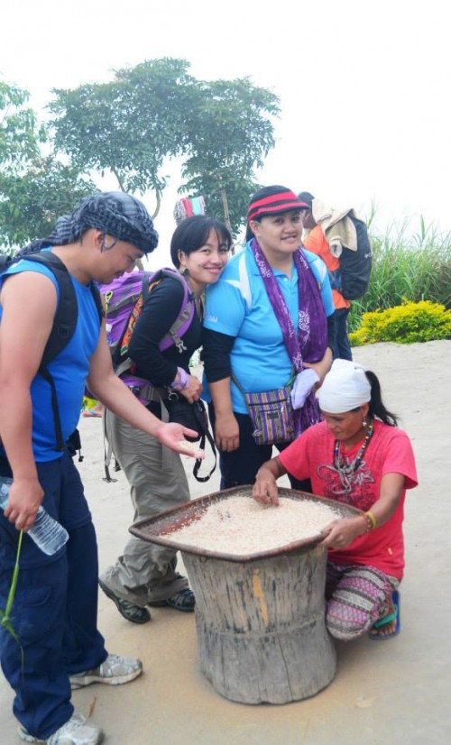
“Balay”, in the local dialect, means “house” or “home”. The village of Balay in the Tuglao West barangay, however, apparently got its name from a plant, the exact details of which are hazy to me, so I won’t delve into it to avoid errors. From the Tuglao West barangay proper, we set off for Balay, the “jump-off” point for Mt. Mosimos.
(This is the second part of a multi-part post series on Trailblazing Tinglayan 2014, the Mt. Mosimos Climb. Check out Part 1 of the series here.)
Leaving the “town proper” of Tulgao East behind, we passed through rice paddies, which impressed us, since we are witnessing traditional farming methods, from the cultivation to the irrigation. No sprinklers in sight, no machines. Just man, his ingenuity, and the bounty of the good ole earth.


On the way, we could see the path laid out for us, and from our vantage point, we spotted several people (locals) going up to Balay. Already, it looked daunting.


It was a 30- to 45-minute hike before we reached a river and crossed the bridge.


You know something’s up when you see the guides (in this case, Sir Mario and Manong Daniel) sitting down waiting and telling everyone to rest for a bit. We were just getting winded and we are being told to rest?
Yes, we are, because from the end of the bridge, it’s a continuous uphill climb. Some may liken it to the Akiki trail going up Mt. Pulag. Only this one is in the open, with no shade or canopy to protect you from the glaring heat of the sun. Sure, there were a couple of trees, but they were so far apart, and the reprieve was just, well, fleeting. Note that we are making this uphill (“upmountain” would be more appropriate) in the middle of the day.


The view was exhilarating, though. Whenever we stop and look down, a humbling feeling comes over you. If you have a bad case of vertigo, however, you might want to refrain from looking down too much.


The first signs that we’re nearing “civilization” are the rice paddies. There’s also the sound of a waterfalls nearby, which we only caught glimpses of.

There was also a shed where we rested for a good 10 minutes or so, refilled our water supply from a mountain spring. Then resumed walking.
Another sign we’re getting close to the village: these walkways.

I’ve never been so happy to see a building in my life (that’s an exaggeration, but at the time, that’s what I felt).


Our first welcome to Balay.

Balay has 17 households and a population of around 60. There is no electricity, but we saw solar panels being used. It’s generally a sleepy little town, and it’s hot, hot, HOT.

According to the locals, led by Manong Noel, education is one of their biggest problems. The kids can’t get proper time at school, since there are no teachers. There is one who is willing to make the long and arduous trek up to Balay, but she can only come around once a month, then have to go back down again. You can feel the eagerness of the people to have their children go to school, but the circumstances are set against them.

And, yes, there’s the obligatory coffee, and this time, it has pancakes, too! Cooked the old-fashioned way. No ovens here, people!

After a late lunch in the home of Manong Noel, we mounted our gear and prepared to begin our trek to Mt. Mosimos. Manong Noel and one of their kagawads (whose name I forgot – fail) is coming with us, so now we have a total of 4 guides. That makes our group 13-strong.

On our way out Balay, some of the locals insisted we grab some grass, tie it into a slipknot, and bring it with us. It serves as protection against evil spirits or spirits who would not welcome our presence in the mountain otherwise. We’ve nothing to lose anyway (except get cuts since the grass was quite razor-sharp).
You’ll be walking through brambles and prickly foliage, so I suggest wearing long sleeves and thick materials for your pants.

We arrived at a small creek, where our guides said we’d have to stop to make camp, since it was already dusk, and it would be hours still before we reach the summit. They made quick work of the area, turning it into one of the best campsites I’ve ever slept on. The ground was soft, it felt like we were lying on a mattress. I had a migraine attack that night, but after letting nausea run its course, had the best sleep (on a camping setting) EVER!

We had to turn in quite early since we’re to make our assault (the serious trailblaze) at 4am the next day.
Next post: we go up Mt. Mosimos. See ya then!
